


You should spend about 20 minutes on this task.
The maps below show the centre of a small town called Islip as it is now, and plans for its development. Summarize the information by selecting and reporting the main features, and make comparisons where relevant.
Write at least 150 words.
MODEL ANSWER>>>
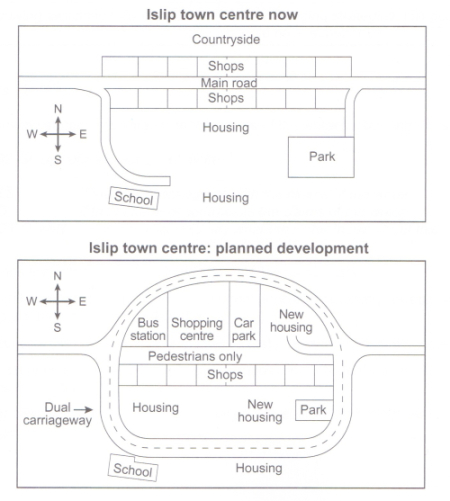
The layout of Islip town at present and its projected developmental plan are portrayed in the given maps.
The town, at present has some shops on either side of the main road which crosses it from West to East. All the establishments are opposite to the countryside, which is at the North. The residential area in the town is at the South, between a school which is located towards the West and a park at the East. Both have access to the main road.
The plan is an enclosed town inside a dual carriage way, which has access points (entry and exit) at both East and West. The new establishments anticipated are a bus station, a shopping centre and a car park, which would replace the existing shops at the North of the main road. The main road, which is the present landmark, is set to be transformed to a pedestrians way. Two new accommodation facilities are expected to the existing ones.
Overall, it is clear that the developmental plan of the Islip town would serve its residents the best.
Word count: 180