You should spend about 20 minutes on this task.
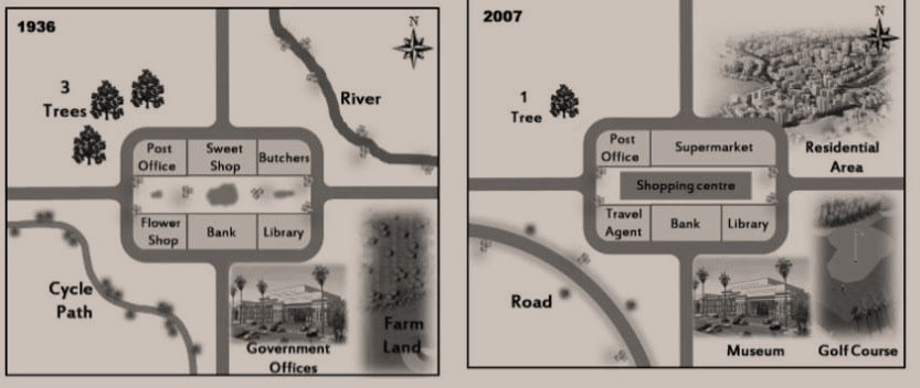
The maps below shows the town of Lynnfield in 1936 and then later in 2007.
Summarise the information by selecting and reporting the main features, and make comparisons where relevant.
Write at least 150 words.
Transformation of Lynnfield between 1936 and 2007 is portrayed in the given maps.
Overall, it is clear that the town of Lynnfield witnessed tremendous changes between the years.
The town consisted of a few commercial establishments and government offices in 1936. The town center, which was well-connected by roads from all four sides, had a post office, sweetshop and a butcher shop at the north end. A flower shop, a bank and a library were there at the south end. Further south, adjacent to the road, some government offices were located.
In 2007, more commercial developments came at the town’s center, with the introduction of a supermarket, replacing the butcher and the sweet shop, and a travel agent, replacing the flower shop. A big shopping center was introduced at the exact middle of the rectangular town center. Government offices were converted to a museum, and a new golf course came towards its east, in place where the farm land existed. The river which was there at the northeast of the town was levelled, and it paved the way for a residential area. The cycle path, which was there on the southwest, was developed to a road and some trees were fell from the northwest.